Toonerville Trolleys: Difference between revisions
No edit summary |
No edit summary |
||
| (13 intermediate revisions by the same user not shown) | |||
| Line 13: | Line 13: | ||
| duration = | | duration = | ||
}} | }} | ||
{{PAGENAME}} were a set of (at least) three trolley cars that circled the park in the early years. | {{PAGENAME}} were a set of (at least) three trolley cars that circled the park in the early years. From old photos, they were numbered 31, 34 and 36. According to a newspaper ad, they opened on AUgust 16, [[1974]]. | ||
It looks like there were three (?) boarding areas: | |||
# The station at [[Main Street]]. | # The station at [[Main Street]]. | ||
# A location behind what is now the [[Der Flinger]] | # A location behind what is now the [[Der Flinger]] | ||
# Where the entrance of the [[Tornado]] is today. | # Where the entrance of the [[Tornado]] is today. | ||
I do not know (yet) why the trolleys stopped running when they did, or even if 1979 is accurate. When the [[Tornado]] wooden roller coaster was opened, its entrance would have replaced the trolley stop. Since [[County Fair]] is listed as opening in 1979, perhaps that was the | I do not know (yet) why the trolleys stopped running when they did, or even if 1979 is accurate. When the [[Tornado]] wooden roller coaster was opened in [[1978]], its entrance would have replaced the trolley stop. Since [[County Fair]] is listed as opening in 1979, perhaps they could have both existed for a bit? | ||
The [[1980]] park map listed "Main Street Depot" and showed some track along the front, but there was no drawing of the Trolleys or any other track on the map. It seems by 1980, they were most certainly gone. | |||
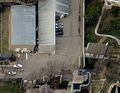
There is a building behind the [[Chapel]] area that was used by the Trolleys. You can still see train track in the ground back there. Today the building is used as the carpentry/wood shop for the park, and the large trolley-sided doors have been redone (but the outlines of the original openings still seem to be there). You can see this from Bird's Eye map views in Bing or Google maps. | |||
In [[1985]], new, smaller track would be placed with a shortened route and become the path for the [[A-Train]]. | In [[1985]], new, smaller track would be placed with a shortened route and become the path for the [[A-Train]]. | ||
| Line 26: | Line 31: | ||
== Photos == | == Photos == | ||
<gallery> | <gallery> | ||
TrolleyStop2016.jpg|Old trolley stop near Der Flinger. | |||
TrolleyStop2016-2.jpg|Old trolley stop near Der Flinger (aerial view). | |||
TornadoEntrance2016.jpg|Former trolley stop. | |||
TrolleyTracks2016.jpg|Old trolley tracks visible from the exit of Tornado. | |||
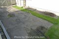
TrolleyTracks2016-2.jpg|Old trolley tracks visible backstage. | |||
</gallery> | </gallery> | ||
| Line 31: | Line 41: | ||
=== Track still visible === | === Track still visible === | ||
You can still see a bit of trolly track from the exit of the Tornado. As you go down the exit ramp, look to the right and you will see it in the concrete near the back of the game buildings. | You can still see a bit of trolly track from the exit of the Tornado. As you go down the exit ramp, look to the right and you will see it in the concrete near the back of the game buildings. | ||
=== Loading area still visible === | |||
While riding the [[A-Train]], you will see a concrete pad near [[Der Flinger]]. This was once a trolley stop. If you view it from the in-park walkway, you will see the trees are not planted randomly. They line up in two rows, which was likely the path leading to the trolley stop. | |||
=== More track still visible (but not to us) === | |||
Behind the [[Chapel]] are some service buildings, and some of the trolley track is still visible there, as well. But, the only way we get to see it is from above. Check it out in BING Maps here: https://binged.it/2bcyzgK Or in Google Maps here: https://goo.gl/maps/nuh9Cr5HuE52 | |||
== External Links == | == External Links == | ||
* https://binged.it/2bcyzgK - BING Map showing trolley tracks backstage. | |||
* https://goo.gl/maps/nuh9Cr5HuE52 - Google Map showing trolley tracks backstage. | |||
* https://binged.it/2aZqtMl - BING Map showing old trolley stop. | |||
Latest revision as of 14:31, 1 September 2016
| DISCLAIMER |
|---|
| Information on this site is unofficial. It is compiled by fans of Adventureland amusement park in Altoona, Iowa (near Des Moines). There may be inaccuracies and omissions. For official Adventureland information, visit the official website. |
See Newest Pages or all Recent Changes. | Join my Facebook Group. | About this site. | Blog | Contact me.
This page was last updated on 09/1/2016. Total Pages: 317. Total Files: 327.
Home / Extinct Rides - Toonerville Trolleys
|
MISSING PHOTO | |
| Name | Toonerville Trolleys |
|---|---|
| Category | Family Ride |
| Type | Train |
| Park Area | Main Street |
| First Year | 1974 |
| Final Year | 1979 |
| Riders | INFO NEEDED |
| Dispatch Rate | INFO NEEDED |
| Ride Duration | INFO NEEDED |
| About the Ride Info Box | |
Toonerville Trolleys were a set of (at least) three trolley cars that circled the park in the early years. From old photos, they were numbered 31, 34 and 36. According to a newspaper ad, they opened on AUgust 16, 1974.
It looks like there were three (?) boarding areas:
- The station at Main Street.
- A location behind what is now the Der Flinger
- Where the entrance of the Tornado is today.
I do not know (yet) why the trolleys stopped running when they did, or even if 1979 is accurate. When the Tornado wooden roller coaster was opened in 1978, its entrance would have replaced the trolley stop. Since County Fair is listed as opening in 1979, perhaps they could have both existed for a bit?
The 1980 park map listed "Main Street Depot" and showed some track along the front, but there was no drawing of the Trolleys or any other track on the map. It seems by 1980, they were most certainly gone.
There is a building behind the Chapel area that was used by the Trolleys. You can still see train track in the ground back there. Today the building is used as the carpentry/wood shop for the park, and the large trolley-sided doors have been redone (but the outlines of the original openings still seem to be there). You can see this from Bird's Eye map views in Bing or Google maps.
In 1985, new, smaller track would be placed with a shortened route and become the path for the A-Train.
Photos
-
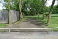
Old trolley stop near Der Flinger.
-
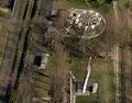
Old trolley stop near Der Flinger (aerial view).
-
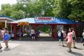
Former trolley stop.
-
Old trolley tracks visible from the exit of Tornado.
-
Old trolley tracks visible backstage.


Trivia
Track still visible
You can still see a bit of trolly track from the exit of the Tornado. As you go down the exit ramp, look to the right and you will see it in the concrete near the back of the game buildings.
Loading area still visible
While riding the A-Train, you will see a concrete pad near Der Flinger. This was once a trolley stop. If you view it from the in-park walkway, you will see the trees are not planted randomly. They line up in two rows, which was likely the path leading to the trolley stop.
More track still visible (but not to us)
Behind the Chapel are some service buildings, and some of the trolley track is still visible there, as well. But, the only way we get to see it is from above. Check it out in BING Maps here: https://binged.it/2bcyzgK Or in Google Maps here: https://goo.gl/maps/nuh9Cr5HuE52
External Links
- https://binged.it/2bcyzgK - BING Map showing trolley tracks backstage.
- https://goo.gl/maps/nuh9Cr5HuE52 - Google Map showing trolley tracks backstage.
- https://binged.it/2aZqtMl - BING Map showing old trolley stop.